Hello, Oswego! The busy time that is early October, full of tests, papers, and club happenings is winding down. This means it’s time for a quick review of what has happened so far this month.
The first half of the month has felt much more like September than October. Average highs this time of year are in the lower 60s, with lows in the low to mid 40s. Through today (the 15th), we’ve had 10 days exceed 65º, 5 exceed 70º and 1 (the 5th) exceed 80º. Factoring in the relatively warm low temps we’ve experienced, and the average temperature has been over 5º above normal thus far into the month!
The month, so far, has featured its fair share of interesting weather and sunsets, as well.
First off, the remnants of Hurricane Nate, which made landfall near Biloxi, Mississippi on the 8th, impacted the region the following day. 2.87″ of rain fell on Oswego in a 12-hour period! No flooding was noted, as the area had been very dry prior to the rain falling. Nearby Watertown, NY recorded 3.67″ from the event, their wettest October calendar day ever recorded.
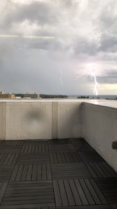
Perhaps most striking (ha!), was a thunderstorm the evening of the 5th. A passing cold front combined with warm and humid conditions initiated scattered showers and storms, one of which approached Oswego via Lake Ontario. I managed to capture the shot above using my iPhone’s slo-mo video feature.
With warm, dry high pressure frequenting the Northeast this autumn, clearer skies have meant more great sunsets. This one was captured on the 2nd of the month.
More dry, mild conditions and great sunsets are in the offing this upcoming week as high pressure returns. Have a great week!


