Hello once again, Oswego!
This past Thursday night (Dec. 8), campus experienced one of the world’s wildest wonders of nature: Thundersnow.

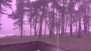
Screen capture from a video I had rolling during the thundersnow, around 11:15 Thursday night. It almost looks like daytime!
It is exactly as it sounds: Lightning and thunder that occurs while it is snowing outside. While rare for any part of the globe, it is about a once or twice-a-year occurrence here in Oswego.
The process that goes into creating thundersnow is very similar to that of an ordinary thunderstorm. In a nutshell, a charge separation builds up between the clouds and the ground, and a discharge in the form of lightning ensues. However, it is much harder to create this charge separation during the colder months.
Here in Oswego (or anywhere near a Great Lake, for that matter), we have a secret weapon: Lake Ontario. During lake effect snow, combinations of conditions can come together to create such a charge separation. For this event, there were three main factors. The first was the “background” ongoing lake effect snow event, which had dropped well over a foot of snow on the Tug Hill. Lake effect circulations provides lift to the atmosphere, creating tall, thick clouds capable of producing precipitation (in this case, snow). Second, an incoming cold front provided a boost to this lift. Third, small circulations known as mesovortices developed within the lake effect snow band. This created “cells” with appearance on radar similar to a summertime pop-up thunderstorm. All of these factors combined to generate enough of a charge separation for lightning in the Oswego area.
Other areas away from the Great Lakes experience thundersnow as well, however conditions aren’t usually favorable in other systems (think nor’easters) as often as they are in lake effect.
So, now you know why Jim Cantore goes wild every time he experiences thundersnow. In the upcoming week, several chances for snow exist, namely Sunday night and Thursday-ish. Keep an eye to the sky late week if you’re traveling home.
I’ll resume posts at the end of January. Have a great winter break!


