Hello everyone! What a week it has been. We all could use a break from midterms, right?!
As always, there’s been some excitement here in Oswego, weather-wise. Let’s get to it.
Saturday, Oct. 8, ended on a brilliant note. As the sun set, the clouds lit up like fire. The surrounding landscape glowed of yellow as the sky became very bright. As the sun continued to set, the color morphed from yellow, to bright orange, to deep pink. It was a surreal experience to stand at the lakeshore and look at the best sunset of the semester so far.
Thank (in part) Hurricane Matthew for the extreme sunset. The clouds from the system, well to Oswego’s south at the time, streamed north, but the edge of the clouds ended just below the horizon as seen in the photo above. This allowed the setting sun to briefly illuminate the clouds from underneath, creating an effect known as afterglow. Afterglow is fairly common among most sunsets, however this intensity is probably only a twice-a-year occurrence in Oswego.
Then, on Oct. 13, a weather system moved through the Great Lakes, bringing with it some morning rain showers. Later in the afternoon, the dreaded Oswego wind moved in. Large waves ensued as the wind blew out of the northwest, some of which likely exceeded 5 feet in height. As the waves came in, some would crash into the rocky shoreline and have nowhere to go but up. Not a good day for boating!
Don’t be fooled, however, waves around here can (and have) reached 10-15 feet in height. Come wintertime, I’ll probably come back to this topic for one reason or another.
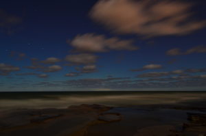
The night of Oct. 13, Oswego had a chance to see the Aurora Borealis. I walked down to the lake around 9:50 pm to snap some shots with my camera. While I did not succeed in photographing the aurora, I did still walk away with this cool view of Lake Ontario at night. However, aurora were sighted and photographed around nearby Rochester, as well as several other locations in the Great Lakes region.
Why the lack of visible aurora here in Oswego? A couple reasons. 1) The nearly full Moon added a lot of light pollution to the sky, making it harder to spot the relatively dim aurora. 2) There may have been a “substorm”, or brief uptick in auroral activity, that initiated the flurry of aurora sightings in the region. At the time, Oswego had cloudy skies, with clearing taking place shortly after the time of those reports. Substorms normally do not last more than an hour or two, so Oswego may have just missed the viewing window. Tough luck on this one!
The upcoming week looks like pretty typical fall roller-coaster weather, with near-daily rain chances, warm temps to start the week (chant enough and we might reach 80 on Tuesday!), followed by cooling as the week progresses. Until next time, Oswegonians!!!


