Hello, Oswego!
You’ve now survived 5 weeks of classes, and spring break is less than 2 weeks away!
Mother Nature appears to have taken her own sort of spring break this week. Normally, we’d still be in the 30s at this time of year with the threat of snow storms. However, temperatures have soared above 60º on several days, putting spring fever into full effect. Crazy!
As a matter of fact, many locations in the Northeast and Midwest U.S. have set new *all-time* February record high temperatures. A large-scale pattern shift prompted the warm temperatures. High pressure, which brings fair weather, took hold over the eastern US last weekend. The high acted to pull warm air from the South northward, and coupled with the usual heating a location receives from the Sun, produced anomalously warm temperatures as a result. Further, a storm system late this week helped draw even warmer air northward. Syracuse, NY set its all-time February high of 71º on Friday. That kind of warmth is normal for late-May!

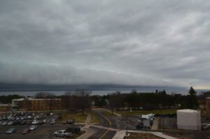
Thunderstorm shelf cloud as seen from Shineman on Saturday, Feb. 25. This storm was along the front that put an end to the Spring-like warmth of late. (Sad face.)
Here in Oswego, a number of interesting factors came into play while the warm spell was ongoing. Most notably, on Friday, while Syracuse and other parts of CNY basked in 70-degree warmth, Oswego remained in the 40s much of the day. This was due to a stationary front, or a separation of warm and cool air masses that (relatively speaking) does not move, that set up shop just to the south of Oswego. Later that evening, when this front lifted northward, campus warmed from 38º to 65º in about one hour!
This upcoming week looks like a roller coaster of temperatures. Midweek looks mild, while next weekend looks wintry. Hang on tight, folks, spring is just around the corner!


